Mount Bigelow

Mount Bigelow (also called the Bigelow Range and Bigelow Mountain) is a long mountain ridge with several summits. It is located in Franklin County and Somerset County, Maine, sixty-nine miles north-northwest of Birch Rock. It is Maine's fifth highest summit. The mountain is named after Major Timothy Bigelow who climbed the rugged summit in late October 1775. Major Bigelow was one of Colonel Benedict Arnold's four division commanders during the 1775 Invasion of Canada. Major Bigelow's expeditionary force into Canada passed along the Dead River on the northern edge of the Bigelow Range, now dammed into Flagstaff Lake.
The highest summit of Bigelow Mountain is West Peak, at 4,145 feet. Subpeaks include Avery Peak at 4,088 feet, The Horns at 3,805 feet, Cranberry Peak at 3,194 feet, and Little Bigelow Mountain at 3,070 feet.
Bigelow Mountain is part of the Rangeley-Stratton mountain range, which also includes other Maine 4000 footers Sugarloaf, Crocker, Saddleback Mountain, Abraham, Redington, and Spaulding.
The Appalachian Trail traverses Bigelow Mountain. Much of the mountain and surrounding area is part of the 10,540 acre Bigelow Preserve created in 1976.
The Appalachian Mountain Club considers both the West Peak and Avery Peak of Bigelow to be "four-thousand footers" because Avery Peak rises more than 200 feet above the col that adjoins it to the higher West Peak. By this same criteria, the South Horn of Bigelow, while under 4,000 feet, qualifies for the New England Hundred Highest list.
Pictures
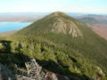
Avery Peak, Mount Bigelow's second highest peak
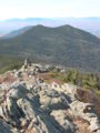
The Horns
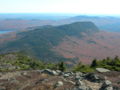
Little Bigelow Mountain, 3,070 feet
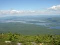
Flagstaff Lake viewed from Mount Bigelow


